
FOUR PARKS IN GRAVENHURST CLOSED DUE TO FLOODING, AS SOME MUSKOKA ROADS STILL SHUT DOWN WHILE WATER LEVELS UP AND DOWN
Mark Clairmont | MuskokaTODAY.com
MUSKOKA — Flood waters continue to rise in parts of the district, while receding in some others.
And that’s causing reverberations throughout the adjoining watersheds.
In Gravenhurst, effective immediately, the town has posted signs closing public parks on Lake Muskoka and Sparrow Lake including:
- Muskoka Bay Park
- Lorne Street Beach
- Muskoka Beach Park
- Franklin Park – Kilworthy
They say in a release today the closures are to protect the public from flood-related debris and the fast fluctuation of water levels.
Staff will address any debris cleanup after water levels recede.
And they hope to reopen the parks as soon as possible.
Due to flooding, the town has also closed some public areas of Muskoka Wharf, including the boardwalk and municipal docks.
Also closed is the area where the RMS Segwun and Wenonah II are docked, plus the HISSO (Muskoka Steamships and Discovery Centre) ticket office, which is currently protected by an AquaDam.
Businesses remain open unless these businesses note otherwise.
People living along the banks of Lake Muskoka and Sparrow Lake should take steps to protect their property from rising water levels.
See the Town of Gravenhurst website or District of Muskoka website for flood-related information.
Sandbags are available for the public at various locations in Gravenhurst. See our website for details.
Elsewhere, as of Tuesday, April 21:
- In Bracebridge River Road and Thompson Road remain closed as
- In Huntsville water levels have started to decrease at the Williamsport Monitoring Station, Rivercove, Old North Road, and Glen Acres. And have stabilized in the downtown core. Areas along the Muskoka River, south of the Brunel Locks and Port Sydney will continue to see high water levels as water makes its way through the system.
- In Lake of Bays public works crews are actively patrolling and monitoring roads and responding where water is affecting roadways. Residents are encouraged to report road washouts, flooded roadways, or other road related concerns at lakeofbays.on.ca/Report-It or call (705) 635-2851.
- District of Muskoka reports As a result of flooding in Muskoka in the last decade and through the Integrated Watershed Management Projects, the District undertook Floodplain Mapping Projects (FPMP) to better identify areas at risk of seasonal flooding.

As of today parts of the park at the Muskoka Wharf are are closed. But for more than a week it has been seen visitors visiting it, including Taran Kaur, Rabie Kaur and Vick Singh, of Toronto, who saw water levels rise as the snow and ice melted in Gravenhurst Wednesday.
Why floodplain mapping?
The goal of floodplain mapping is to have more information to assist with emergency management plans and help inform development.
The FPMP identifies areas that are most at risk of flooding. Floodplain mapping is critical to support informed decisions and investments to reduce the impacts of flooding in our communities. Development in these areas can result in damage to buildings and possessions if flooding occurs; in extreme cases loss of life could occur.
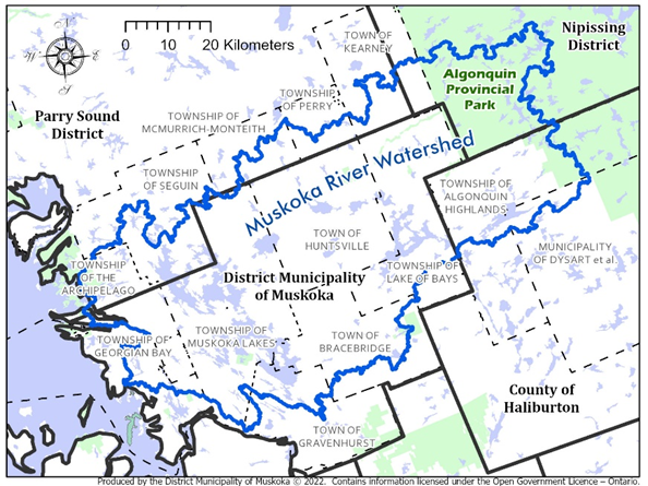
About Muskoka watershed:
It measures over 62 kilometers at its widest point and is approximately 120 kilometers long, encompassing an area of approximately 5,100 square kilometers. The watershed contains over 2,000 lakes and almost 7,000 km of shoreline.
There are three main watersheds within Muskoka.
- The Black-Severn River Watershed flows through the Severn River to Georgian Bay in the southern portion of the District.
- Muskoka River (North and South Branch) Watershed outlets into Georgian Bay through the Moon and Musquash Rivers.
- In the western portion of the western portion, a narrow band of the Georgian Bay Watershed conveys flows to Georgian Bay through several smaller rivers in the Township of Georgian Bay.
The district’s Muskoka River Water Management Plan is a legally enforceable strategy outlining how the 42 dams in the watershed operate to manage the flow and water levels in the Muskoka River with a focus on maintaining water levels for navigation, fish and wildlife, and hydropower generation. The plan was created in 2006 and is managed by the Ministry of Natural Resources and Forestry (MNRF).
Following the massive 2019 flooding the province provided $5 million for water management.
In April 2021, Onario announced an initial investment of over $4 million to fund twelve projects aimed at examining the existing conditions in the Muskoka River Watershed and exploring ways to reduce the impacts of flooding and to address its health. The district continues to leadi all these projects, in partnership with the Muskoka Watershed Council.
Why floodplain mapping?
The goal of floodplain mapping is to have more information to assist with emergency management plans and help inform development.
The FPMP identifies areas that are most at risk of flooding. Floodplain mapping is critical to support informed decisions and investments to reduce the impacts of flooding in our communities. Development in these areas can result in damage to buildings and possessions if flooding occurs; in extreme cases loss of life could occur.
See also their flood links at:
Muskoka Floodplain Mapping Primer
Muskoka Floodplain Mapping Project Pamphlet
📧 Contact, Subscribe, Advertise
Email: news@muskokatoday.com
Subscribe: E-transfer $30 to news@muskokatoday.com
Mail: MuskokaTODAY.com, Box 34, Gravenhurst, ON P1P 1T5
Advertise: Email news@muskokatoday.com for rates