
DIGGING DEEPER INTO FOWLER’S MEGA QUARRY EXPANSION IN BRACEBRIDGE
Lois Cooper | MuskokaTODAY.com
BRACEBRIDGE — Fowler Construction’s application to increase the size of it’s quarry licence along Bonnie Lake Road, in Macaulay Township, from 580 acres to 983 acres; with an extraction license for 852.8 acres gained approval by the Bracebridge town council last week (Oct. 12, 2022).
It was rezoned to “Extractive Industrial Quarry Special-2 (M3Q-2) from Extractive Industrial Quarry Special-1 (M3Q-1) and Environmental Protection Wetlands-1 (EPW1).”
Of the many studies commissioned by Fowler’s, the traffic study was performed from 7-10 a.m. to 4-7 p.m., leaving the daily number of trucks currently unaccounted.
The traffic study states: current peak hour trips at 28 and with the new zoning up to 254 peak hour trips, suggesting 100 peak hour trips will happen.
Currently 200,000 tons are removed yearly; the new zoning allows for 10 times that amount or 2 million tons a year.
Blasting vibrations are said to be minimal. And noise is expected to be between 110 and 124 decibels — based on measurements taken 10 years ago.
Fowler’s noise impact assessment description of operations is as follows:
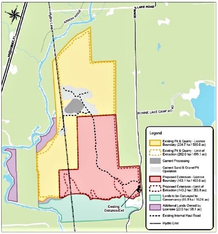
- After initial stripping of the overburden, the extraction will proceed from the existing licensed area to the Phase A of the extension, in a southerly/easterly direction.
- Next, the extraction will proceed to Phase B of the Extension, also progressing in a southerly/easterly direction. The sequence of extraction is presented graphically in the site plan, dated June 2020.
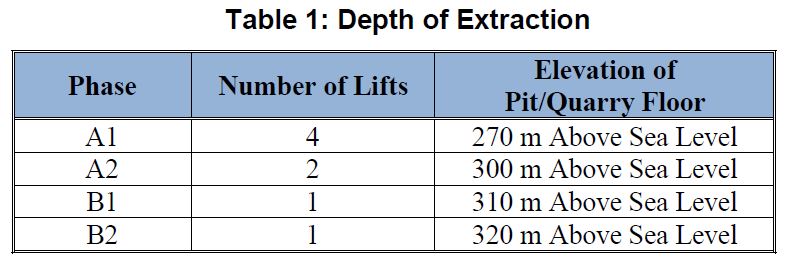
- The raw materials will be extracted in up to four lifts, each 15 metres deep.
- The following table summarizes the number of lifts needed and the final height of the pit/quarry floor in each phase.
See Table 1: Depth of Extraction below
- A rock drill will operate either at the top of the terrain or atop the lift, where extraction is taking place, boring holes in the rock into which explosives will be packed and the rock blasted from the working face.
- Following a blast, a front-end loader will transfer loosened rock to a primary crushing plant operating near the working face.
- From the primary crushing plant, the processed materials will be transferred via a series of belt conveyors to the main processing area within the existing pit, which includes a series of crushers, screeners, and a wash plant.
- Finished products will be loaded by a front-end loader into highway trucks and shipped off-site, via the main entrances on Bonnie Lake Road.
Existing and proposed pit and quarry licence boundary
The wetland study determined there are 37.5 hectares (92.7 acres) of wetland with a containment area of 219 hectares (541 acres).
The report describes the type of wetland as:
- Fen, swamp and marsh scoring 50 out of 70 in rarity type of wetland;
- No endangered or threatened species listed;
- Provincially significant animals listed — midland painted turtle and snapping turtle 80/178 points;
- Provincially significant plants listed — black ash 50/178 points;
- It is not suitable for black ducks 0/20;
- Colonial nesting water birds is 0/50;
- Winter cover for wildlife is 0/100;
- Water bird staging or moulting is 0/150;
- Waterfowl breeding — habitat not suitable 0/150;
- Passerine, shorebird or Raptor stopover 0/150;
- Ungulate habitat 0/150 (no moose);
- Fish habitat is not present;
- Spawning and nursery habitat 0/100.
Final determination: The wetland is not provincially significant; allowing for it to be destroyed.
Muskoka Conservancy did not comment to the Town of Bracebridge on the application to extend the license from 580 to 983 acres.
Neither did the Friends of the Watershed or the Muskoka Watershed Council.
The Muskoka Watershed Council is funded mainly by public dollars.
In an email from them they said: “As a longstanding policy, MWC does not comment on site-specific issues and so we are not regularly circulated on planning applications.”
Muskoka Conservancy did gain a new reserve — the Sage Creek Nature Reserve on land adjacent to the lands rezoned to allow the extension of quarry/gravel pit. The 65 hectares (162.6 acres) includes 1.6 kms of Sage Creek from the Bonnie Lake Road to the north branch of the Muskoka River.
According to the Muskoka Conservancy website:
‘Muskoka Conservancy studied the property,
and view it as an important natural area.’
According to the Muskoka Conservancy website: “Muskoka Conservancy studied the property, and view it as an important natural area. Sage Creek is a cold-water stream featuring Brook trout. Sage Creek Nature Reserve was donated in 2021 by Fowler Construction.”
Fowler’s gave away 162 acres of wetland that was and is protected under environmental zoning.
Re-zoned and made available to Fowler’s for aggregate operations were 92.7 acres (37.5 hectares) wetland with a containment area of 541 acres (219 hectares), according to a Wetland Evaluation Report commissioned by Fowler’s.
An additional water study for Fowler’s on 37.5 hectares (92.7 acres) of wetland claims that the new aggregate operations “will not affect ground water, deep water within the granite, or water quality for fish and animals to a depth of 270 metres above sea level (ASL).”
There is permission to go to 190 m ASL in depth in part.
Neighbouring wells could be affected
Wells within 400 metres of the aggregate site have been measured. Those whose wells have not been measured should contact the Town of Bracebridge.
Fowler’s is to operate a monitoring program and those who experience well water problems in the future can contact Fowler’s.
Fowler’s states in an email to the town: “Anyone interested in having their well surveyed is welcome to contact John McBride at Fowler Construction at 705-646-5725 or jmcbride@fowler.ca
“When a request is received, it will be assessed to determine if it is an appropriate well to be surveyed. (e.g. the well is assessable to be surveyed and within the potential area of groundwater influence from the proposed quarry).”
The town’s Comprehensive Zoning By-Law 2016-088 requires a minimum setback of 60 metres (196.8 feet) from any property boundary for an aggregate operation.
The re-zoning by-law passed requires 60 metres on the front yard. Zero metres setback for commonly held yards is applied. The external property boundaries other than the front yard appear to have no setback.
Depreciation of neighbouring properties and businesses is not a consideration states a town staff report.
The town’s director of planning and development indicates “the notice of passing of the zoning by-law amendment is expected to be mailed the week of Oct. 24 to those who made comment during the process and it will not come into effect until the 20-day appeal period has expired.
“If the matter is appealed to the Ontario Land Tribunal, it will not be in effect until the board has issued a decision on any appeal.”
After that the Ministry of Natural Resources and Forestry deals with processing the licence.
Lois Cooper owns a farm on Hwy. 117 near the quarry application site.
EMAIL: lois@muskokatoday.com
28 years of ‘Local Online Journalism’
Twitter: @muskokatoday, Facebook: mclairmont1
Leave comments at end of story
SUBSCRIBE for $25 by e-transferring to news@muskokatoday.com
Or go online to https://muskokatoday.com/subscriptions