
FLOODING FUELLED BY DOUBLE NORMAL RAIN IN APRIL
MUSKOKA — Weather watchers (and aren’t we all here, now) will be interested to know that Environment Canada pretty much predicted the recent rains that have contributed to flooding across much of Muskoka.
They say Central Ontario received about double their normal monthly precipitation amount.
And, not too surprisingly, they say in a release Friday that April’s showers are not over yet.
As for May, the beginning of this month there appears to be little change in their May 3 model.
They say a west to east jet stream pattern over the southern Canadian latitudes is supporting frequent disturbances, i.e. seasonal temperatures with average to above-average precipitation.
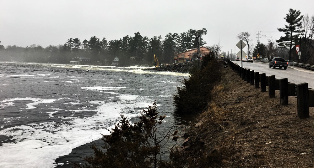
As for April, they don’t need to tell us, but they say it was extremely active weather-wise and was dominated by the flooding emergency across central and eastern Ontario after mid-month.
While a number of factors contributed to the severity of this year’s spring flooding, it is worth highlighting a couple of them, says Chantale Cerny, of Climate Services for Environment Canada/Meteorological Services of Canada.
Cerny’s release says the winter was long and cold and characterized by higher-than-normal snowfall across central, northern and eastern Ontario.
Many winters have one or two significant thaws, which allow the snow load to diminish slightly, and some water to run off.
However, there were only a few more minor thaws this winter leaving plenty of snow still on the ground in early April.
Although, the snow pack did begin to disappear fairly rapidly by mid-month. Secondly, as discussed below, there were a number of strong synoptic-scale (large) storms that produced significant rainfall in the latter half of the month across the province.
Those rainfalls contributed significantly to the flooding, in addition to water levels on the Great Lakes (especially Erie and Ontario) and as a result the St. Lawrence River, giving rise to emergencies last seen in the spring of 2017.
Temperatures and Precipitation
Temperatures in April ranged from normal to below normal values in Ontario. Portions of the northwest, far north and south had temperatures in the normal range, while most of the province experienced temperatures below normal by 1-2°C.
The greatest temperature anomalies (up to -3°C) were observed in Northern Ontario.
Aside from parts of northwestern Ontario and the Far North, that were drier than normal, the province received above-normal precipitation amounts in April.
The regions to the northeast of Lake Superior, east of Georgian Bay and Central Ontario received about double their normal monthly precipitation amount.
In terms of snow depth, at the end of March, the province was still under a thick blanket of snow. There were large areas northeast of Lake Superior, east of Georgian Bay and Central Ontario that had more than 60 cm of snow on the ground. In contrast, at the end of April, the snowpack has almost completely disappeared from the province, except for thinner snowpacks that linger in portion of northern Ontario.
Significant Events
April 26-27: Another storm
Yet another low pressure system developed over the southern US on the 25th of April and moved northeastward towards Ontario bringing more heavy rain, focussed on southwestern and central Ontario and the upper Ottawa River watershed region of western Quebec.
Windsor Airport reported 32 mm, Goderich 40 mm, Muskoka 36 mm, Kirkland Lake reported 43 mm, Muskoka 36 mm, while eastern Ontario reported lesser amounts (Ottawa 13 mm).
April 29: Winter still not over for Thunder Bay
To end the month, a trough of low pressure extending north from a centre of low pressure in Minnesota produced a late-spring snowfall of 10-15 cm for Thunder Bay, with one report from Murillo, west of the city and over higher terrain, of 20 cm.
While rare, such late spring snowfalls have happened before; there was a report of 22 cm on May 2, 1954, in addition to a couple reports of 2 cm of snow as late as May 22.
April 30: Rain still in the forecast for eastern Ontario
While it did not fall until the following day, it was painful for many eastern Ontario residents under flood warnings to hear of more rain forecast for the first day of May.