WARM MONTH AND WARM LAKE CAUSED LOCAL LAKE EFFECTS STORM NOT SEEN HERE SINCE 2009
Mark Clairmont | MuskokaTODAY.com
GRAVENHURST — This weekend’s storm was the worst to hit south Muskoka in 15 years in terms of length and intensity.
Not since Dec. 10-12 of 2009 has anywhere near this amount of snow hit the area with the enormous “lake effect” wallop of Nov. 28-Dec. 1.
And that was just over 100 cms, Geoff Couslson a warning preparedness meteorologist with Environment Canada said this afternoon after researching and finding the numbers when asked for by MuskokTODAY.com.
This weekend it was 125 to 140 cms — that’s 49 to 55 inches. Or more than 4.5 feet.
The impact remains widespread, with the Gateway to Muskoka town even “specifically requesting that people from outside the area not make their way to Gravenhurst.
“This includes individuals wanting to check cottage properties. Additional vehicle traffic in the community is a hindrance to cleanup.

Even Coulson called this a “huge” weather event.
He said Environment Canada no longer measures accumulation at the Muskoka Airport.
And he warned it’s not over yet as soon as Wednesday and two more weeks beyond.
So don’t expect a green Christmas in three weeks even if temperatures rise slightly they won’t melt the amount of snow dumped, he forecast.
S-NOTES:
- Effective 7 p.m. tonight, the Gravenhurst Centennial Centre is open as a formal reception centre for people needing accommodation. The centre is at 101 Centennial Dr. The following amenities are available at the site: beds, food, water and showers. The reception centre is open 24 hours a day and staffed. Watch the town’s website for further updates on the centre. And their website for further state of emergency information.
- TLDSB says Gravenhurst schools will remain closed Tuesday; but all Bracebridge schools will be open with no buses.
So when, how and why … did
great storm of 2024 happen?
He blamed it in parts on a warm November and the length of time the snow fell.
“The event actually got going Thursday evening the 28th. So it was a long-lived event before the band of snow drifted south of Gravenhurst on Sunday.”
Tell us about it.
“The heart of the accumulation occurred from late Thursday in to Sunday morning. And then the action shifted down more toward Barrie and Collingwood, where the bands tended to weaken a little. And they also tended to move around a bit.
“One of the other issues that Gravenhurst and Bracebridge had to deal with was the sheer number of hours that the band locked in almost west to east coming over Georgian Bay and over land and in to those areas. A number of hours of intense bands providing centimetres per hour for a number of hours.”
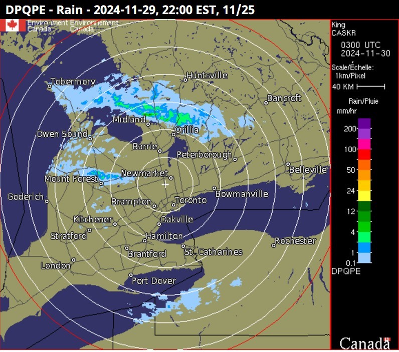
He said he went back and “looked at our radar archives and picked out an image that tends to show the band at one of its strongest points — late in the evening about 10 p.m. Friday the 29th. It’s very typical of what the band looks like coming in from Georgian Bay.
“It’s a radar image from King City radar — north of Toronto. It does a pretty good job of showing how that snow squall band went right in from almost late Thursday night in to Sunday morning.”
He agreed in lay terms that moisture in the air collected over the Great Lake, blew east and dropped it into Muskoka.
“What you’re really looking at is a sharp contrast between the temperature of the waters of Georgian Bay and the temperatures of the Arctic air mass flowing over it. And part of what made this event so significant was just how warm November was, which meant that the temperatures of Georgian Bay stayed much milder than normal for this time of year. So that thermal contrast between the lake and Arctic air mass were pretty extreme.”
The other thing that made this event “so significant” was “the number of hours the winds lined up in that west to east direction. Snow qualls depend on what the low level winds are doing. And if there’s a lot of drifting around of the winds or direct height it can cause the bands to weaken and make the lake effect more widespread, but not necessarily give as much snow.
“But in this particular event it was both long-lived and those low level winds lined up from west to east for a number of hours. So basically a whole series of ingredients coming together to make this a very, very significant lake effect event.”
He said Environment Canada is “categorizing” it as a 2.5 day event — “not necessarily with the band staying locked in one place over that whole time. But shifting gradually back and forth as these lake effect bands are wont to do. Until on Sunday the overall low level pattern shifted it more west and that brought the activity down more into southern Georgian Bay.”
Coulson, who has been doing this since the early ’80s, said he “had to go back. And the closest I could one I could find in the near past was a very significant event that affected Gravenhurst, Bracebridge, Minden Dec. 10-12 of 2009.
“And I’m sure your readers will remember that because it was an event that dumped over 100 cms in roughly the same area. Similar impacts, power outages, road closures, people trapped in their homes for some time.
“Lake effects is something we deal with most winters, last year being a bit of exception because of how warm it was for most of the winter. An average winter we expect to see these Arctic masses in the second half of November, December in to January when Georgian Bay starts to ice up. And this is a huge percentage of the overall winter snowfall in the area that is attributed to lake effect snow.”
With prevailing winter winds frequently from the west that means the eastern shores of Georgian Bay down through Lake Simcoe can experience more of these lake effects.
Coulson said some of the biggest lake effects happen in Ontario because of the way the Great Lakes are and the length of time the waters remain open. He said a similar effect from Lake Superior Monday and Tuesday deposited another 100 cms outside of the Soo.
London and Woodstock were also getting hit today.
Which makes Muskoka not that unusual in Ontario — though more mountainous snow earlier.

Events like this, he said, “can happen in western parts of Newfoundland and off the Winnipeg lakes before they freeze up in Manitoba. And off Lake Nippigon and north western Ontario.
“It’s something people need to beware of,” Coulson said. “But certainly the amount of snow falling in this period is relatively rare. We get big events like a metre of fresh snow, but those events don’t tend to happen very often.”
He said don’t rule out this happening again because of how warm November was and how warm the lakes are now.
“We’re already looking at another potential significant lake effect snow event firing up Thursday in the wake of a system coming through on Wednesday that’s gonna give a general snowfall that won’t add too much to what you’ve got. But will cover a larger area.”
In addition overall models indicate winter temperatures are expected to be colder than normal or at least seasonal.
“So we’ve moved out of that temperature trend of warmer than normal conditions in November to more seasonal to somewhat colder. And if the winds line up and other factors come in to play there could be more lake effects snow in the coming weeks.
“So it’s really important for the readership to be watching the forecast from Environment Canada (where most sources get their weather information). Watching for those snowfall warnings. Watching the radar online or the weather apps on their phone. Because we know how localized this activity is. You can be sunny in one part of the area and drive five kms north and it’s different.”
He added: “I think for you guys it’s hard to believe you will get rid of all that snow by Christmas. Even with some milder temperatures there’s gonna be more lake effects in the coming days to add what you’ve already got. Look, if there’s anywhere for a safe bet for a white Christmas you’re right on the list. Certainly we could get a mild spell before Christmas and put a dent in the snow path. But right now it’s looking, overall, like December will be more seasonal temperature-wise for your area.”
To keep on top of the government weather, the warning preparedness meteorologist recommends his WeatherCAN – Canada.ca app.
“That’s one of the ones I recommend. It’s a good one to use because it tends to get the watches and warnings from Environment Canada as soon as they are issued.
“But the Weather Network has a good app. There’s number of others out there. I recommend people just try some of the ones that pop up on their app store and try them out. What I may like somebody else may not. So it’s really personal preference in a lot of ways. And all of these apps are getting the basic information from Environment Canada, especially when it comes to watches and warnings.
“It’s just what’s nice about the WeatherCAN app is it’s gotta fairly clean presentation. You got radar on there if you want to look at it and quick access to watches and warnings.”
Or go to MuskokaTODAY.com for the latest weather info link.
Coulson concluded: “It’s just started. We have a lot more winter to go, Mark, so I’m sure we’ll be chatting as the weeks and months go by.”
EMAIL: news@muskokatoday.com
30 years of TRUSTED ‘Local Online Journalism’
SINCE MAY 20, 1994
Twitter: @muskokatoday, Facebook: mclairmont1
SUBSCRIBE for $30 by e-transferring to news@muskokatoday.com
Mail cheque to MuskokaTODAY.com Box 34 Gravenhurst, Ont. P1P 1T5
And include your email address to get stories sent to your inbox

